AT75, vicinity Bukoba, Tanzania, 2022
AT75, vicinity Bukoba, Tanzania, 2022
Summary
On 6 November 2022 adverse weather delayed an ATR42 beginning its visual-only approach to Bukoba. When an approach was commenced, adequate visual reference was not maintained due to continued adverse weather. No corrective action was taken in response to three successive automated excessive descent rate alerts or the first officer’s calls to reduce descent rate. Although response did follow a ‘PULL UP’ warning, it was too late to prevent a high-energy impact with the surface of Lake Victoria close to the shoreline, and both pilots and 17 of the passengers were killed.
Flight Details
Aircraft
Type of Flight
Public Transport (Passenger)
Flight Origin
Intended Destination
Take-off Commenced
Yes
Flight Airborne
Yes
Flight Completed
No
Phase of Flight
Descent
Location - Airport
Airport
General
Tag(s)
Approach not stabilised,
Visual Approach,
PIC aged 60 or over
CFIT
Tag(s)
Into water,
No Visual Reference,
Vertical navigation error,
VFR flight plan
HF
Tag(s)
Authority Gradient,
Inappropriate crew response - skills deficiency,
Ineffective Monitoring,
Manual Handling,
Plan Continuation Bias,
Procedural non compliance,
Ineffective Monitoring - PIC as PF
WX
Tag(s)
In Cloud on Visual Clearance,
Precipitation-limited IFV,
Strong Surface Winds
EPR
Tag(s)
Emergency Evacuation
Outcome
Damage or injury
Yes
Aircraft damage
Hull loss
Non-aircraft damage
No
Non-occupant Casualties
No
Occupant Injuries
Few occupants
Occupant Fatalities
Many occupants
Number of Occupant Fatalities
19
Off Airport Landing
No
Ditching
No
Causal Factor Group(s)
Group(s)
Aircraft Operation
Safety Recommendation(s)
Group(s)
Aircraft Operation
Air Traffic Management
Airport Management
Investigation Type
Type
Independent
Description
On 6 November 2022 an ATR 42-500, (5H-PWF) operated by Precision Air on a scheduled domestic passenger flight from Dar es Salaam to Bukoba as PW494 encountered adverse weather at the visual approach-only destination. After a short delay, the captain decided to commence a visual approach to runway 31 in day instrument meteorological conditions (IMC). The prevailing weather was not conducive to this. Below 500 feet, after EGPWS ‘SINK RATE’ alerts were ignored despite the first officer’s calls to reduce rate of descent, an EGPWS ‘PULL UP’ warning followed. This was followed by a nose-up input on the control column, but it was too late to prevent a hard impact with the surface of Lake Victoria close to the runway threshold. This severely damaged the aircraft and rendered it beyond economic repair. Seventeen of the 39 passengers on board were killed as were both pilots. There were no serious injuries to the 24 occupants who survived and only one minor injury to one of the cabin crew.
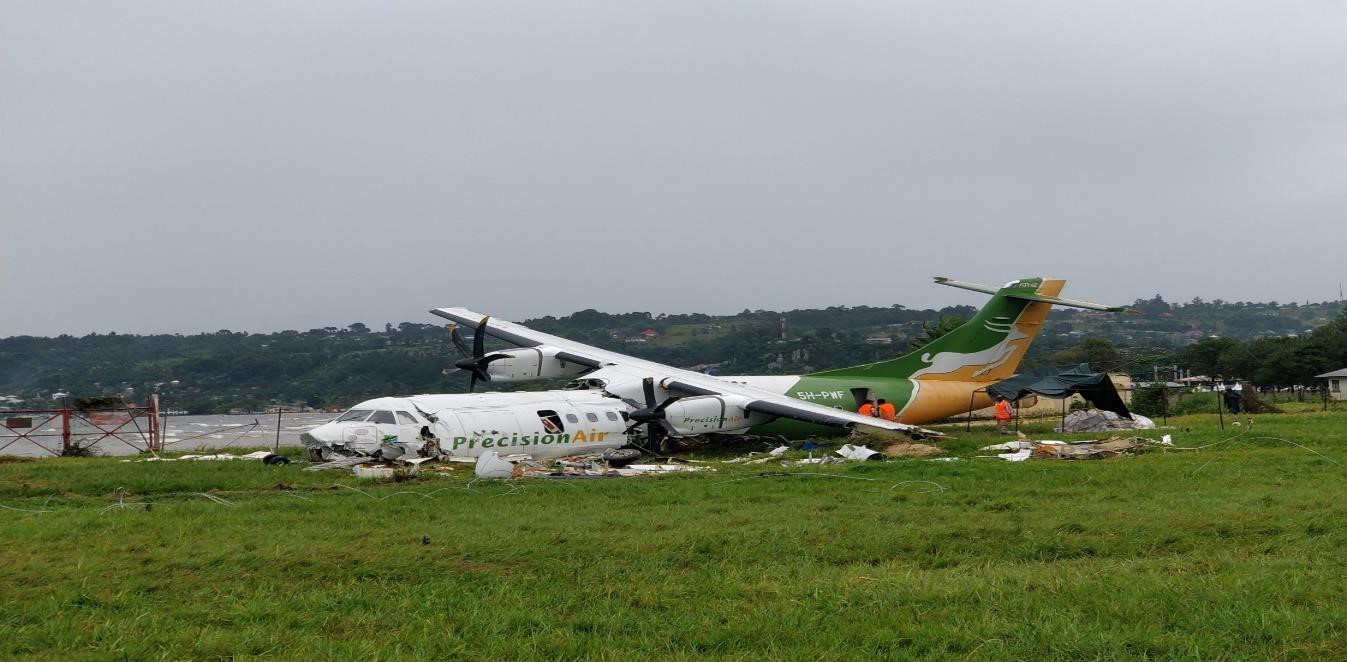
The aircraft after recovery from Lake Victoria.
[Reproduced from the Official Report]
Investigation
An investigation was carried out by the Tanzania Ministry of Transport Aircraft, Accident and Incident Branch with assistance from the French BEA. The flight data recorder (FDR) and cockpit voice recorder (CVR) were both recovered, and their data formed an essential part of the investigation. The 64-year-old captain had a total of approximately 23,515 hours flying experience, of which 11,919 hours were in command on the ATR42/72. He had flown 29 hours in the 28 days prior to the accident, including 13 hours in the previous 7 days. He was also the operator’s chief pilot and current as a training captain. The 46-year-old first officer had a total of 2,109 hours flying experience, which included 1,700 hours on type. He had flown 74 hours in the 28 days prior to the accident including 23 hours in the previous seven days.
What Happened
The flight from Dar es Salam was to make a stop at Bukoba and then proceed to Mwanza before returning to Dar es Salam. After an uneventful cruise at FL200, descent was commenced after almost two hours airborne. An initial weather report for Bukoba provided by Mwanza Approach - there was no provision for air traffic service at Bukoba - gave the weather there as compatible with a visual approach, with the surface wind calm. As the descent continued, “signs of poor weather conditions were experienced” over Lake Victoria. The crew recognised the possibility that the approach to the single runway might have to be made from the mountainous inland direction rather than the essentially overwater approach from the east. When the flight reported to Mwanza approach control that they had Bukoba in sight, it was cleared to change to the unmanned Bukoba air/ground frequency. Positioning for a visual approach to runway 13 was commenced with the captain acting as pilot flying (PF).
It soon became apparent that the weather conditions no longer favored a visual approach to runway 13. The captain decided they would descend to 5,000 feet QNH (Bukoba is 3,740 feet amsl) and track towards a position to the southwest of the airport with a view to joining a base leg to runway 31 (see the illustration below).
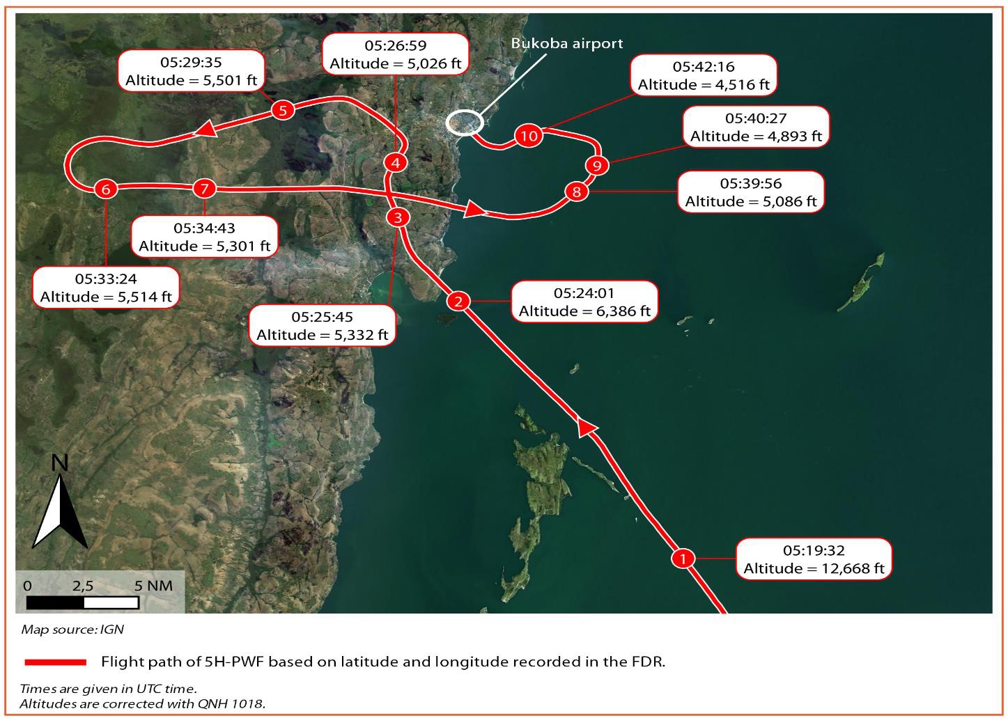
The aircraft ground track annotated with altitude and time (Z).
[Reproduced from the Official Report]
The landing checklist was completed but when the runway was still not visible, the captain decided not to continue. The landing gear and flaps were raised and the aircraft climbed to an altitude of 5,500 feet. Although the first officer suggested diverting to Mwanza, the captain initially decided to remain to the west of Bukoba to await an improvement in the weather. This improvement did not occur. The captain then passed control to the first officer and instructed him to position back to Lake Victoria. The captain then made a PA announcement to advise passengers that they had been unable to land at Bukoba due to heavy rain and would await an improvement in the weather, and should it not occur, they would proceed to Mwanza.
A single EGPWS ‘TERRAIN PULL UP’ warning occurred whilst still over land but there was no crew response or comment. Soon afterwards, the aircraft was back over Lake Victoria around 1,300 feet above its surface. As they approached the runway 31 extended centreline (see the illustration below), the captain asked the first officer if he could see Musila Island (which is located close to the approach track at 1.5 nm from the runway threshold with a summit 118 feet above the lake surface) and he confirmed that he could. However, the report says over the next 78 seconds "the flight crew was trying to locate Musila Island to no avail."
As the flight initially continued northeastwards about 5/6 nm from Bukoba, flap 15 was selected, the landing gear was selected down and the rate of descent initially set to 1,000 fpm. A flap setting of 25° was followed by full flap (35°), and a few seconds later, the captain called “speed 102,” which was confirmed by the first officer. This was followed almost immediately by the captain calling “watch your speed, speed, speed, need power, a lot of power,” and the power levers were moved forwards to a recorded 62°. As the aircraft was leveled off at around 900 feet over the lake, a left turn towards a close-in right base was completed. Shortly after this, the first officer said that he could see the runway, although it was obscured by rain and the captain did not confirm a sighting at that time.
As a right turn onto final approach over Musila Island was about to begin, the captain instructed the first officer to “go a bit lower.” Shortly after establishing on final approach, the captain called “runway in sight” and took over as PF with about 1½ nm to go to the runway threshold. He disconnected the autopilot (AP) and set the power levers to flight idle. The descent rate increased to 1,700 fpm and with an estimated 1.2 nm to go until the runway 31 threshold, and the captain told the first officer to “watch height” which the first officer acknowledged. The first officer added that the crosswind from the right was varying between 19 and 28 knots.
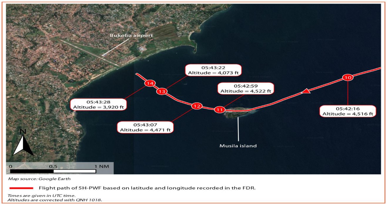
The final stages of the approach.
[Reproduced from the Official Report]
Ten seconds later, the aircraft passed a height of 500 feet over the lake surface. Almost immediately, with the rate of descent still unchanged at 1,700 fpm, the automatic 500-foot agl radio altimeter call was annunciated, followed two seconds later by an EGPWS ‘SINK RATE’ warning. Four seconds after this, the aircraft was just over half a mile from the runway threshold at 300 feet above the lake surface (the runway threshold was only 20 feet above the lake), and with the rate of descent reduced slightly to 1,300 fpm, the captain called for the first officer to select condition levers to maximum. A second ‘SINK RATE’ warning occurred almost immediately and was followed by a nose down input on the control column.
Five seconds after a third ‘SINK RATE’ warning occurred, by which time the descent rate had increased back to 1,700 fpm. The first officer responded by calling, “Lift up, captain” which was immediately followed by a ‘SINK RATE PULL UP’ warning. A very small reduction in the rate of descent was recorded but there was no verbal response from the captain. As the first officer shouted, “Pull up, captain” the aircraft impacted the lake surface with a rate of descent recorded as 1,500 fpm.
Water contact occurred with the aircraft 2° nose down and 10° left bank with the left wing tip first to touch the water. This resulted in an almost 180° rotation of the airframe to the left. It was concluded that this led directly to “the separation of the left wing tip, the radome, the nose landing gear and the left main landing gear, which in turn ripped open part of the main floor allowing water to flood the cabin." The aircraft finally came to a stop 385 metres from the shoreline and 500 metres from the runway 31 threshold with the damaged forward fuselage below the water line. Damage to the aft fuselage was minimal, and the fact that it was not fully submerged meant that survivors in that section were able to escape via the main passenger door into canoes and small fishing boats which took them ashore.
The official Marine Rescue boat operated by the Bukoba Police Marine Unit did not arrive at the scene until over 5 hours after the accident as “it was on patrol duties away from Bukoba port." By this time, “one of the local fishermen who had his own oxygen equipment, had started the process of recovering the dead bodies from the wreckage." It was noted that the Bukoba rescue and firefighting service (RFFS) unit was “not equipped for offshore operations."
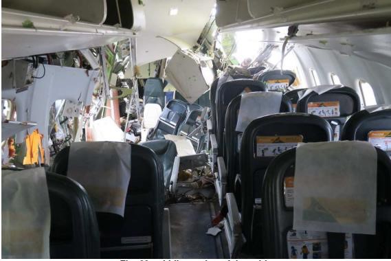
The rear cabin viewed from mid cabin after recovery of the aircraft from the Lake.
[Reproduced from the Official Report]
The ICAO requirement for a pathological and toxicological examination of the deceased pilots and passengers was not satisfied. An examination of the recovered bodies “reported that all bodies recovered from the wreckage showed signs of death by suffocation,” which was taken to imply the victims drowned.
Why It Happened
There was no published approach procedure for Bukoba. The approach that preceded the accident was unstabilised. Given that the captain did not respond to the four EGPWS ‘SINK RATE’ alerts over a 15-second period, nor to the first officer’s own calls to pull up, it was considered that for unknown reasons, “during this time the [captain] had already lost situational awareness.”
The required minimum visibility of 5km and minimum cloud ceiling of 1,560 feet aal for an approach and landing at Bukoba was met when Mwanza passed the latest weather observation (METAR) during the initial descent. The subsequent weather deterioration did not initially prevent the crew from reporting that Bukoba was in sight, so the flight was transferred to the unmanned air/ground frequency at Bukoba. As a result, although a “drastic change” in conditions had been subsequently observed by the Bukoba Meteorological Office and resulted in a special weather observation (SPECI), which gave both visibility and cloud base as below minima, and had been communicated to Mwanza Approach, there was no way it could be passed to the aircraft.
The Cause the accident was formally recorded as an unstabilised final approach to runway 31 of Bukoba airport conducted in poor weather conditions which did not allow clear view of the terrain and which led the aircraft to strike the lake surface.
Seven Contributory Factors were identified as follows:
- The decision of the pilot in command to proceed with the final approach without the required weather minima in order to reach the runway instead of diverting to Mwanza;
- The gusting crosswind which prevailed at the time of final approach;
- The heavy rain and turbulence during the approach;
- The absence of air traffic services at Bukoba Airport;
- High rate of descent at low altitude;
- No immediate response to the EGPWS warnings;
- High workload to the crew at the critical phase of final approach.
Eight Safety Recommendations were issued based on the investigation findings as follows:
- That the Tanzanian Civil Aviation Authority should ensure that instrument approaches are developed and published for all visual flight rules (VFR) airports which have scheduled commercial flights.
- That the Tanzania Civil Aviation Authority should ensure that air traffic services are established at Bukoba Airport.
- That Precision Air Services shall comply with minima and conform to the procedures as stated in their standard operating procedures (SOPs).
- That Precision Air Services and other operators should always stick to weather information supplied by official sources.
- That the Tanzania Airport Authority (TAA) should ensure that (the) Bukoba Rescue and Fire Fighting Service (RFFS) is strengthened by including water rescue capability.
- That the Tanzania Ministry of Health should ensure that qualified medical doctors are available to conduct autopsy in accordance with ICAO Standards and Recommended Practices.
- That Precision Air Services should implement flight data monitoring procedures to support SOP (compliance).
- That the Air Navigation Service Provider at Mwanza airport should amend the relevant procedures to include provisions to transmit critical weather information to aircraft that have already tuned their radios to the unmanned frequency (118.2 MHz).
Safety Action take whilst the Investigation was in progress were noted as including the following:
- A performance-based navigation (PBN) procedure has been developed and published for Bukoba airport.
- The weather reports for Bukoba are now being transmitted to Mwanza Approach every 30 minutes.
The Final Report was published on 18 January 2025.