CRJ7 / H60, vicinity Washington National DC USA, 2025
CRJ7 / H60, vicinity Washington National DC USA, 2025
Summary
On 29 January 2025, a Mitsubishi CRJ700, operating a scheduled airline flight on short final approach to land on runway 33 at Ronald Reagan Washington National in night VMC collided with a U.S. Army Sikorsky UH60 helicopter. The helicopter was on a training flight using a designated restricted-height route which intersected the runway 33 extended centreline. The UH60 had requested and received ‘own separation’ from the other traffic. This route had a maximum height of 200 feet agl but no lateral limits. Both aircraft were destroyed, and there were no survivors.
Flight Details
Aircraft
Operator
Type of Flight
Public Transport (Passenger)
Flight Origin
Intended Destination
Take-off Commenced
Yes
Flight Airborne
Yes
Flight Completed
No
Phase of Flight
Descent
Flight Details
Aircraft
Operator
Type of Flight
Military/State
Flight Origin
Intended Destination
Take-off Commenced
Yes
Flight Airborne
Yes
Flight Completed
No
Phase of Flight
Descent
Location - Airport
Airport
General
Tag(s)
Aircraft-aircraft collision,
Airspace Design,
Copilot less than 500 hours on Type,
Flight Crew Training,
Helicopter Involved,
PIC less than 500 hours in Command on Type,
Visual Approach
LOS
Tag(s)
Released to Own Separation,
Mid-Air Collision,
Military Aircraft involved,
VFR Aircraft Involved
Outcome
Damage or injury
Yes
Aircraft damage
Hull loss
Non-aircraft damage
No
Non-occupant Casualties
No
Occupant Fatalities
Most or all occupants
Number of Occupant Fatalities
67
Off Airport Landing
No
Ditching
No
Safety Recommendation(s)
Group(s)
Air Traffic Management
Investigation Type
Type
Independent
Description
On 29 January 2025, a Mitsubishi (formerly Bombardier) CRJ700 (N709PS) operated for American Airlines by their subsidiary PSA Airlines on a scheduled domestic passenger flight from Wichita to Ronald Reagan Washington National Airport (DCA) as AA5342 was on short final and cleared to land on runway 33 at destination. At approximately 300 feet agl in night visual conditions (VMC), the CRJ collided with a U.S. Army Sikorsky UH60 helicopter assigned to ‘Priority Air Transport’ work and based at Davison Army Airfield, approximately 11 nm southwest of the accident site. This helicopter was on a visual flight rules (VFR) training flight and at the time was heading south with the CRJ700 reportedly in sight. The wreckage of both aircraft fell into the Potomac River and all 67 occupants of both aircraft were killed.
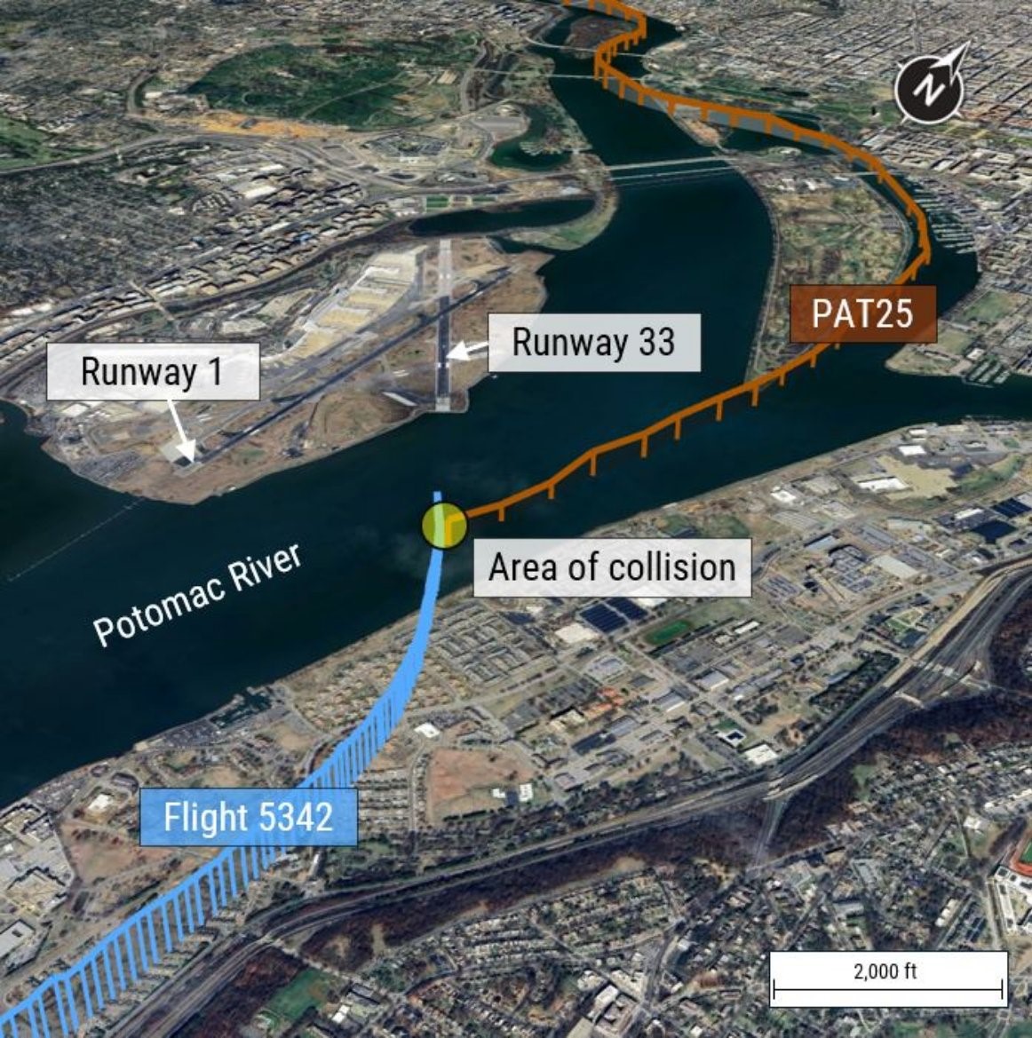
The ground tracks of both aircraft based on preliminary ADS-B data. [Reproduced from the Official Report]
Investigation
An accident investigation is being carried out by the U.S. National Transportation Safety Board (NTSB). The cockpit voice recorder (CVR) and flight data recorder (FDR) from the CRJ700 were recovered and all relevant data downloaded. The helicopter was fitted with a multipurpose flight recorder (MPFR) from which relevant recorded data from both the voice and flight data units were also successfully recovered. The CVR component of this recorder contained about two hours of data, but flight data from it was more problematic. It was found that the air data source for a parameter listed in the documentation provided as “barometric altitude” was actually a recording of pressure altitude and “a review of the recorded pressure altitude values revealed that they were inconsistent with other available data” and thus assessed as invalid. It is not yet known if the invalid pressure altitude data was merely a problem in respect of the MPFR or whether other systems that used pressure altitude as a data source may have been affected.
The CRJ700 captain had a total of approximately 3,950 hours flying experience which included approximately 3,024 hours on type and the first officer had a total of approximately 2,469 hours flying experience which included approximately 966 hours on type. During the accident flight, the captain was acting as pilot flying (PF) and the first officer as pilot monitoring (PM). The UH60 flight crew consisted of an instructor pilot with approximately 968 hours flying experience of which approximately 300 hours were on type, and a pilot with approximately 450 hours flying experience of which approximately 326 hours were on type. A crew chief with approximately 1,149 hours time, all on type, was also on board.
What Happened
Both aircraft had been airborne for just over two hours at the time of the collision. The CRJ 700 followed its instrument flight rules (IFR) flight planned route. The UH60 had, after getting airborne from Davison Army Airfield, been engaged in an annual standardisation evaluation for the pilot which involved using night vision goggles. The UH60 first called Washington Tower when it was about 15nm northwest of Washington National Airport - sixteen minutes before the collision – and it was given and correctly acknowledged the altimeter setting of 29.89 inches. Immediately after this, the two pilots then changed roles so that the pilot became PF and the instructor pilot became PM. The instructor pilot then requested clearance to fly southbound on Helicopter Routes 1 and 4 along the Potomac River (see the illustration below) to return to Davison Army Airfield, and this was approved.
A few minutes later, the helicopter began descending as it picked up Route 1 to head southeast towards downtown. Meanwhile, Potomac Approach was clearing the CRJ700, which was inbound from the south for a visual approach to Runway 1 at Washington National. Just over a minute later it established on the instrument landing system (ILS) localizer for runway 01 at approximately 4,000 feet at a speed of 170 KCAS and was then transferred to tower with about 10.5 nm to go. The tower controller asked the CRJ crew if they could circle to land on runway 33. This was agreed with a landing clearance for that runway subsequently given and read back.
At this time, the helicopter was about 1.1 nm west of the Key Bridge with CVR data recording the PF indicating that they were at 300 feet followed by the PM saying that they were at 400 feet. No comment from either pilot about an altitude discrepancy followed and one minute later, as the helicopter approached Key Bridge, the PM was recorded saying that the helicopter was at 300 feet descending to 200 feet.
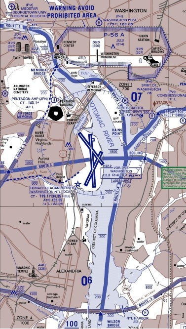
Excerpt from the FAA Chart showing the area around Washington National Airport. [Reproduced from the Official Report]
As the helicopter passed over the Memorial Bridge, the CVR recorded the PM telling the PF that they were at 300 feet and needed to descend and the PF saying that they would descend to 200 feet. At this time, the CRJ700 crew disconnected the autopilot (AP) and, from approximately 5 nm south of the airport, began a shallow right turn away from the Runway 01 localizer at a radio altitude of approximately 1,700 feet to circle for runway 33. Just over half a minute later, a radio transmission from the tower was audible on the CRJ700’s CVR informing the helicopter that “traffic just south of the Wilson Bridge was a CRJ at 1,200 feet circling to Runway 33”. However, “CVR data from the helicopter indicated that the portion of the transmission stating the CRJ was ‘circling’ may not have been received [...] The word is heard in both recorded in ATC communications and the CRJ700 CVR, but not on the helicopter CVR." The relative position of the two aircraft at this time was as shown on the illustration below. The helicopter crew responded that the traffic was in sight and requested they maintain visual separation, which was approved.
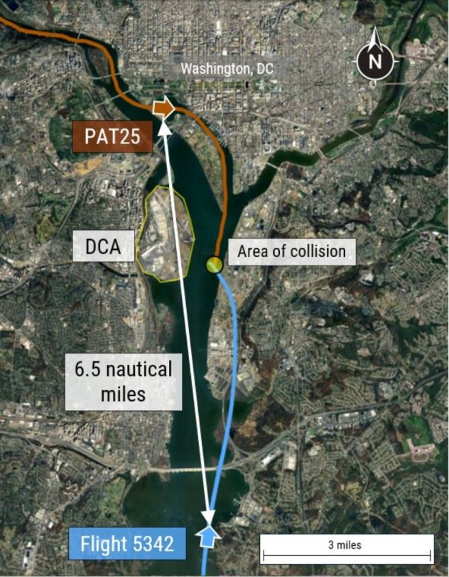
Both aircraft tracks and their positions as the CRJ700 began positioning to runway 33. [Reproduced from the Official Report]
One minute 20 seconds later - and with just over half a minute to go before the collision occurred - the helicopter passed the discretionary reporting position at the southern tip of Hains Point. The CRJ700 began a left roll to turn to final on runway 33 at a recorded 516 feet agl and 133 KCAS. At 20 seconds before impact, a tower transmission audible on both CVRs was made with an ATC conflict alert active in the background asking the helicopter crew if they had the CRJ700 in sight. At about the same time, a Traffic and Collision Avoidance System traffic alert (TCAS TA) (which is aurally inhibited below 400 feet agl) was recorded on the CRJ700 CVR. At this time, the two aircraft were just under 1nm apart as depicted in the illustration below.
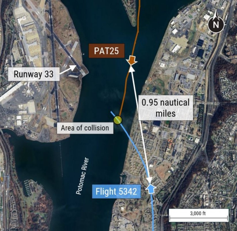
The approximate positions of both aircraft 20 seconds prior to the collision. [Reproduced from the Official Report]
With no immediate response from the helicopter crew, the tower controller followed up with a direction that the helicopter “pass behind the CRJ." An almost immediate response from the helicopter “indicated that the traffic was in sight and requested visual separation, which was approved” but the helicopter CVR data “indicated that the portion of the transmission that stated ‘pass behind the’ may not have been received by the crew” as a 0.8-second transmission had been stepped on by their response to the call. Following this response, the helicopter CVR then recorded the PM telling the PF that “they believed ATC was asking for the helicopter to move left toward the east bank of the Potomac".
Six seconds later - 7 seconds before impact - the CRJ700 completed its repositioning onto the Runway 33 final approach at a recorded 344 feet agl and at a recorded speed of 143 KCAS. FDR data from the CRJ700 showed that two seconds before impact, the last recorded radio altitude was 313 feet and that one second before impact, the CRJ's elevators were deflected near their maximum nose-up travel. The collision occurred with the CRJ at 9º nose up and 11º left wing down with the descent at 448 fpm.
FDR data from the helicopter indicated that its radio altitude at the time of the collision was 278 feet and that this had been maintained for the previous 5 seconds. A preliminary review of available video evidence indicated that all the landing, navigation, anti collision beacon and strobe lights on the CRJ700 were illuminated prior to the collision, as were the helicopter's navigation and strobe lights.
Why It Happened
At this early stage in the Investigation, the full background to what happened remains far from complete. However, one key finding concerns the way that the U.S. Federal Aviation Administration (FAA) defines the dimensions of the airspace which is depicted on their charts as ‘Helicopter Routes’.
According to FAA Order 7210.3EE, ‘Facility Operation and Administration’ “FAA Helicopter Route Charts are graphic portrayals of discrete and/or common helicopter routes or operating zones designed to facilitate helicopter access into, egress from, and operation within high density traffic areas (and) generally include associated altitude or flight ceiling information to facilitate traffic avoidance and pilot adherence to minimum safe altitude requirements”. However, the FAA has advised that “helicopter routes have no defined lateral boundaries and are drawn to depict linear paths along defined surface features in a manner legible to flight crews” although “any applicable lateral distance restrictions will be shown in the chart specifications or in warning boxes displayed on the chart”.
There were no lateral distance constraints on Helicopter Route 4, only a maximum height of 200 feet agl when in the vicinity of Washington National Airport despite the fact that it intersects with the final approach to runway 33. The consequences of this omission in respect of the accident location, although not necessarily to the accident under investigation, are evident. Even if a helicopter were to route along the east riverbank, it would only have about 75 feet of vertical separation from an aircraft approaching runway 33 on the nominal PAPI-guided approach path and this separation decreases if the helicopter is operated further from the river bank as occurred in the accident or if an aircraft is operated below the standard 3° visual glidepath provided.
The Investigation has already sought to put this aspect of the accident in context by examining data on low-level conflict between helicopters and fixed wing commercial transport aircraft in the vicinity of Washington National Airport. It has found that “at least one TCAS RA was triggered per month due to proximity to a helicopter” and that in over half of these events, the helicopter involved may have been above the route altitude restriction. It was also found that almost 70% of these events had occurred at night and that in a period of just over three years ending in December 2024, there had been 85 events involving a lateral separation of less than 1,500 feet concurrent with a vertical separation of less than 200 feet.
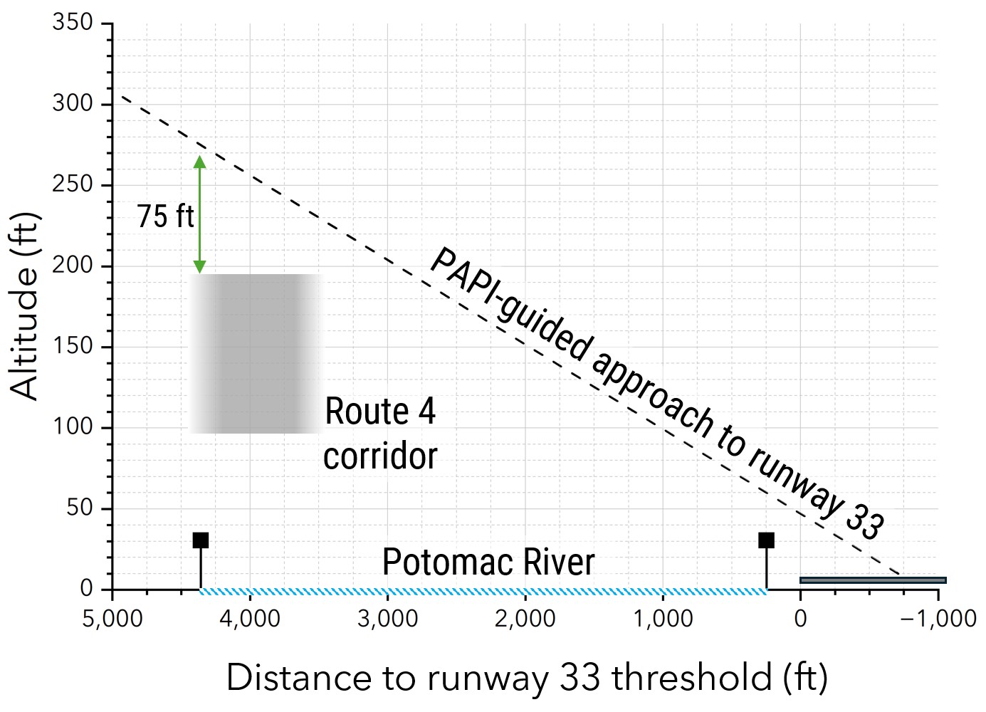
The reducing separation between Route 4 helicopter traffic and aircraft on short final to runway 33 as distance from the east bank of the Potomac River increases. [Reproduced from Aviation Investigation Report AIR-25-01]
The NTSB has noted that because of the circumstances of the accident, Notice to Airmen (NOTAM) action has since temporarily restricted any use of Helicopter Route 4. However it has concluded that under the current definition, continued use of the Route would pose “an intolerable risk to aviation safety by increasing the chances of a midair collision." It has also recognised that “total closure of Helicopter Route 4 between Hains Point and the Wilson Bridge during times when runway 15/33 is in use for departures and arrivals, respectively, would restrict a vital aviation corridor used for law enforcement activity, Coast Guard patrols, and continuity of government operations." It has also concluded that “continued access to the most direct course possible is critical for these operations” and since requiring ATC to hold helicopters in place north or south of the airport whilst aircraft are operating on runway 15/33 could increase risk by adding to controller workload, an alternative route which does not increase controller workload is needed.
Accordingly, 2 Urgent Safety Recommendations were made on 7 March 2025 as follows:
- that the Federal Aviation Administration prohibit operations on helicopter Route 4 between Hains Point and the Wilson Bridge when runways 15 and 33 at Ronald Reagan Washington National Airport are being used for departures and arrivals respectively. [A-25-1]
- that the Federal Aviation Administration designate an alternative helicopter route that can be used to facilitate travel between Hains Point and the Wilson Bridge when that segment of Route 4 is closed. [A-25-2]
A Preliminary Report of the Investigation and, separately, a short Report explaining the reasons for the issue of two Urgent Safety Recommendations were both released on 11 March 2025.