D228, en-route, southwest of Mzuzu, Malawi, 2024
D228, en-route, southwest of Mzuzu, Malawi, 2024
Summary
On 10 June 2024, a Dornier 228 impacted terrain near its destination in Malawi when it entered instrument meteorological conditions (IMC) when already operating in marginal visual flying conditions in daylight. The aircraft was destroyed and the three crew and six passengers on board were killed. The accident was attributed to the decision to continue flight at a low height over terrain, a lack of pilot situational awareness and inadequate pre-flight preparation. The passengers on the flight were civilians but the aircraft was owned by the Malawi Government and was operated by the Malawi Air Force.
Flight Details
Aircraft
Type of Flight
Military/State
Flight Origin
Intended Destination
Take-off Commenced
Yes
Flight Airborne
Yes
Flight Completed
No
Phase of Flight
Manoeuvring
Location
Approx.
Nthungwa Forest, Nkhata Bay (Republic of Malawi)
General
Tag(s)
Copilot less than 500 hours on Type,
Inadequate Aircraft Operator Procedures,
Inadequate ATC Procedures,
Ineffective Regulatory Oversight
CFIT
Tag(s)
Into terrain,
No Visual Reference,
Lateral Navigation Error,
Vertical navigation error,
IFR flight plan
HF
Tag(s)
Inappropriate crew response - skills deficiency,
Manual Handling,
Plan Continuation Bias,
Procedural non compliance
WX
Tag(s)
In Cloud on Visual Clearance
Outcome
Damage or injury
Yes
Aircraft damage
Hull loss
Non-aircraft damage
No
Non-occupant Casualties
No
Occupant Fatalities
Most or all occupants
Number of Occupant Fatalities
9
Off Airport Landing
No
Ditching
No
Causal Factor Group(s)
Group(s)
Aircraft Operation
Safety Recommendation(s)
Group(s)
Aircraft Operation
Aircraft Airworthiness
Air Traffic Management
Investigation Type
Type
Independent
Description
On 10 June 2024, a Dornier 228 (registration marking not recorded) operated by the Malawi Air Force on a non-scheduled domestic passenger flight from Lilongwe to Mzuzu in daylight impacted terrain after the flight crew lost forward visibility. They were attempting to manoeuvre both laterally and vertically whilst maintaining visual reference. The aircraft was destroyed by the impact and the nine occupants were killed.
Investigation
An accident investigation in accordance with Annex 13 principles was, at the request of the Malawi Government, delegated to the State of the Manufacturer, Germany. The German Federal Bureau of Aircraft Accident Investigation (BFU) conducted an in-depth Investigation.
In the absence of a flight data recorder (FDR), flight data for both the accident flight and a positioning flight which immediately preceded it were extracted from the recovered Garmin Aera 760 Area Navigation System which had been installed in the aircraft two years earlier. This system included a terrain proximity function which provided terrain or obstacle heights with reference to the current flight altitude in a colour-coded display on the moving map. To show this data on a full-screen display, the pilot must have selected the "map" or "terrain" display on the device. If neither is selected, cautions and warnings are displayed in a pop-up window. Terrain is shown in red if it is above or within 100 ft below the aircraft and in yellow if it is between a user-defined caution elevation and 100 ft below the aircraft. In this case, the caution elevation was set to 1,000 ft.
The 54-year-old male pilot-in-command had a total of 2,367 hours flying experience of which 2,006 hours were on type, and 24 hours within the most recent 90 days. He held a CPL (commercial pilot licence) issued by the South African Civil Aviation Authority and a licence for military pilots issued by the Malawi Air Force, the latter being endorsed for flight instruction. After initially flying the Do228 as a copilot, he had been qualified to fly in command on type since 2008. The 44-year-old female copilot also had a South African CPL and a licence issued for military pilots issued by the Malawi Air Force. She had a total of 722 hours flying experience which included 472 hours on type and had only recently re-qualified on type after “a two year discontinuation for personal reasons.” During and after this process she had flown a total of 23 hours on type, almost 12 of which had been with the captain in command of the accident flight. No evidence of a currently valid medical certification was available for either pilot. A 43-year-old line engineer qualified on the Do228 was also on board.
What Happened
A positioning flight south to Lilongwe took off from Mzuzu at 0704 local time, and after an uneventful flight, landed 48 minutes later. The passengers for the next flight, the Malawian Vice President and his entourage, were to attend a funeral in Mzuzu before being flown back to Lilongwe the same day. While the crew waited for the passengers, the aircraft was refuelled and the copilot filed an IFR flight plan for the flight to Mzuzu. The flight plan showed an estimated flight time 50 minutes and an endurance of four hours with alternates Zomba and Blantyre. It was found that in response to a question from the Aeronautical Information Officer as to why the specified route had stated ‘direct’ rather than route W601 which corresponded to a direct route, she replied that they had experienced bad weather on the inbound flight and intended to fly below the airway. An earlier report from a Government Commission of Inquiry into the accident stated that the crew had not obtained a weather briefing for the northbound return flight from the Lilongwe Meteorological Office, although they had telephoned the Mzuzu flight information service officer (FISO) to check the weather there.
The flight was subsequently cleared to take off and then climb to and maintain FL090. With the copilot acting as pilot monitoring (PM), the aircraft initially followed a direct track towards Mzuzu as shown in the illustration below. The Lilongwe controller stated that the flight had appeared on radar as it passed 4,800 feet and as it approached the control zone boundary had subsequently requested to stop climb at 7,000 feet, which was approved. It then continued on a direct track at that altitude before leaving the terminal manoeuvring area at the NALSA waypoint.
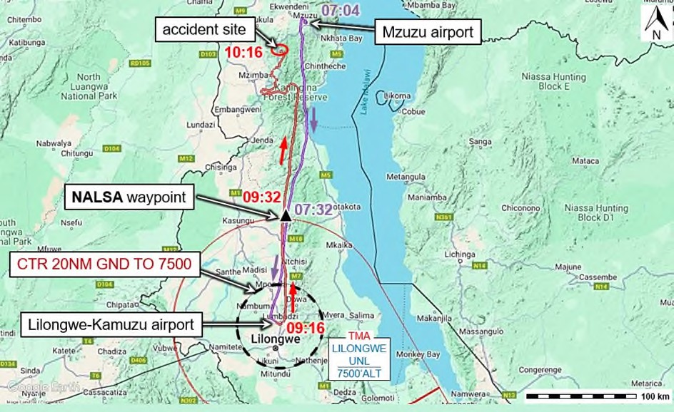
The ground track of both the initial positioning flight (in blue) and the accident flight (in red). [Reproduced from the Official Report]
Several minutes after passing NALSA, the flight began to deviate left of track and begin manoeuvring in a way that indicated an attempt to descend whilst maintaining visual meteorological conditions (VMC) because it was considered that a VMC descent on track was impossible. The subsequent manoeuvring was performed with the autopilot (AP) disconnected. The two following illustrations show the extensive deviation both laterally and vertically, and this was considered indicative of an attempt to remain in VMC whilst in relatively close ground proximity.
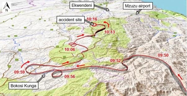
A more detailed depiction of the manoeuvring carried out whilst attempting to remain in VMC. [Reproduced from the Official Report]
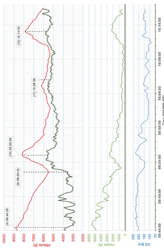
A depiction of the changes in altitude relative to terrain after the deviation from a direct track. [Reproduced from the Official Report]
The search for the crash site was hampered by low visibility, and the Aeronautical Rescue Coordination Centre (ARCC) at Johannesburg was asked for help in finding the aircraft's emergency locator transmitter (ELT) signal. However, this was not possible as the aircraft’s ELT "had been technically obsolete and out of function for many years.” The wreckage was not found by search-and-rescue (SAR) personnel until about 1000 local time the following day.
Impact had occurred approximately 230 feet below the top of a hill and a further 100 feet below the top of a mobile phone mast standing on the summit of this hill. The investigation concluded that “the pilots were unaware that the aircraft was just about to collide with the ascending terrain” and that “this can be explained by the fact that, in the last seconds of the flight, they went into instrument meteorological conditions." At impact, the flaps were set to 5° and the landing gear was down. It was considered that a possible explanation for the flap setting could have been to facilitate slightly slower flight and enable better forward visibility. No reason why the landing gear had been extended could be found.
Why It Happened
Whilst the underlying cause was the attempt by the crew to complete their flight in VMC, the prevailing weather at and to the immediate south of Mzuzu were incompatible with this. Despite the fact that it proved impossible to safely perform a VMC descent and complete the intended flight, the attempt to reach Mzuzu was not abandoned in favour of a return to Lilongwe or a diversion to one of the two alternates.
However, significant wider context for the accident was found by the investigation. This included:
- According to statements from other Malawi Air Force pilots, “going low level in marginal weather conditions corresponded to their usual procedures."
- During this low-level flight, “the flight crew went below the minimum safety altitude several times and over a longer period of time."
- It was considered possible that persistence in trying to reach Mzuzu by a specific time and the need to return the vice president to Lilongwe the same day for a meeting with the president may have resulted in self-imposed or even direct passenger pressure - actual or perceived - to reach the destination as planned.
- The absence of en route forecasts for internal flights despite the existence of a regulatory requirement to make such forecasts available.
- The aircraft involved was on average flown for less than 100 hours per year and the two pilots’ involved averaged only 60-70 flight hours per year without arrangements to compensate for such infrequent experience.
- Analysis of data from the navigation system of the crashed aircraft indicated that there was no sign that squadron pilots used this capability consistently. Whilst some “had entered (and stored) a large number of flight plans to the various aerodromes of the region, as well as a number of waypoints” including the approach to Mzuzu, the two pilots on the accident flight “did not use the potential of the navigation system during their flights on the day of the accident or the day before."
- The absence of any standard operating procedures (SOPs) for use of the aircraft navigation system represented a need for improved risk mitigation. This was assessed to be particularly true in the case of the terrain proximity function of the installed navigation system.
A review of the extent to which Malawi was in compliance with relevant ICAO Standards and Recommended Practices (SARPs) found that the Annex 11 Standard to record radar and radio communications data was not met, which had resulted in information of value to the investigation being unavailable. It also found that the Annex 3 Standard for the National Meteorological Authority to provide meteorological information on an intended flight route was not met and that this was also contrary to the national aviation regulations which required flight crew to familiarise themselves preflight with en route weather information.
The formal Conclusion of the Investigation was that “the accident occurred because the (flight) crew flew into instrument meteorological conditions during flight under visual flight rules and the aircraft collided with the (rising) terrain (ahead)” and that the following had contributed to it:
- The decision to continue the flight to the destination at low altitude in marginal weather conditions.
- A lack of situational awareness.
- Inadequate preflight preparation.
A total of six Safety Recommendations were issued as follows:
Two Recommendations were made in an Interim Report on the progress of the Investigation published on 29 August 2024:
- that the Minister of Defence of the Republic of Malawi should ensure that aircraft of the Malawi Air Force transporting persons are equipped with a functional Emergency Locator Transmitter (ELT). [09/2024]
- that the Minister of Transport and Public Works of the Republic of Malawi should ensure that up-to-date information concerning radio navigation aids in Malawi is available to aircraft crews at all times and that The Department of Civil Aviation should check the proper function of the radio navigation aids and update (the) respective information in the Malawi Aeronautical Information Publication (AIP). [10/2024]
Four additional Recommendations were then made on completion of the Investigation as follows:
- that the Director General of the Civil Aviation Authority of the Republic of Malawi should ensure that air navigation service providers or airport operators record radar data and radio traffic at least at the country's major airports and keep it stored for a period of at least 30 days. [05/2025]
- that the Director General of the Civil Aviation Authority of the Republic of Malawi should ensure that when preparing for their flight, crews can obtain the best possible information about the meteorological conditions (likely to occur) during it (and that) for this purpose, the Department of Meteorological Services should provide meteorological data for the en route phase as well as for planned alternate aerodromes. [06/2025]
- that the Commander of the Malawi Air Force should ensure that aeromedical data of its individual flight crew members are up to date and copies of the latest certificates are stored in their respective military units at all times. [07/2025]
- that the Commander of the Malawi Air Force should ensure that a high level of aviation safety is ensured in the operations of the transport aircraft squadron (and that) to this end, the various possible orders to the squadron should be analysed in terms of their specific risks and risk mitigation measures should be established where necessary. Appropriate standard procedures should be developed or clarified. [08/2025]
The Final Report of the Accident Investigation was published online in June 2025.
Related Articles
- Controlled Flight Into Terrain
- Situational Awareness
- Visual Meteorological Conditions (VMC)
- Instrument Meteorological Conditions (IMC)
- Inadvertent VFR Flight Into IMC
- Minimum Safe Altitude (MSA)
- Pre-Flight Preparation
- Emergency Locator Transmitter (ELT)
- Weather Forecast
- Pilot Fitness to Fly
- Standard Operating Procedures